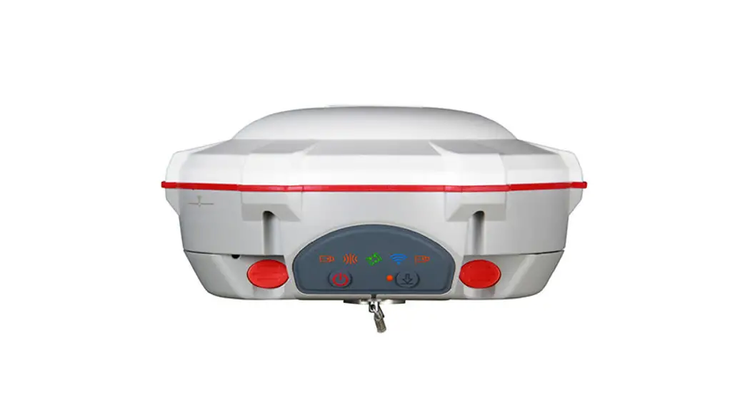
![]() T300 GNSS Receiver
T300 GNSS Receiver
Owner’s Manual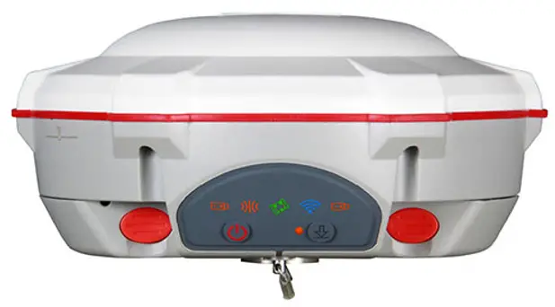 15.8cm
Size: 15.8 cm × 7.5 cm
Weight: 0.95 kg with two batteries
Features
- Support GPS L1/L2/L5, BeiDou B1/B2/B3, GLONASS L1/L2/L3, Galileo E1/E5a/E5b/E6/AltBOC, QZSS L1/L2/L5, Navic L5, SBAS
- Compact Design
- Hot Swap Battery
- User-friendly Interface
RELIABLE IN THE FIELD
SinoGNSS T300 GNSS receiver is a compact RTK GNSS receiver tracking all working constellations, which performs well with each constellation independently. With SinoGNSS QUANTUMTM Generation III technology and its strong anti-interference design, the T300 provides available and reliable high-precision positioning information no matter where you are.
RUGGED AND EASE OF USE
The rugged housing with IP67 Dustproof & Waterproof design makes the T300 work perfectly and effectively even in harsh environments. Small volume with less than 1kg weight makes the T300 one of the most portable GNSS receivers which can meet your RTK survey demands. Bulit-in 8GB internal memory enlarges your data storage in the field.
INTEGRATED GNSS RECEIVER
The T300 GNSS receiver combines a GNSS board, Bluetooth® and adjustable TX/RX UHF into one compact device, which is one of the most reliable choices for any surveying tasks. Built-in GPRS/ GSM/4G modem ensures the T300 work seamlessly with all kinds of CORS.
SMART BATTERY DESIGN
With two hot swap batteries, the T300 extends working hours and ensures your fluent workflow in the field. The battery LEDs flash when battery runs low. The consumer-grade battery design is compatible with Canon LP-E6, which is easy to purchase and replace in your local market.
Signal Tracking
965 channels for simultaneously tracking satellite signals
| GPS | L1C/A, L2C, L2P, L5 |
| BeiDou | B1I, B2I, B3I, B1C, B2a, B2b |
| GLONASS | L1, L2, L3 |
| Galileo | E1, E5a, E5b, E6, AltBOC |
| QZSS | L1C/A, L1C, L2C, L5 |
| Navic | L5 |
| SBAS | WAAS, EGNOS, MSAS, GAGAN, SDCM, BDSBAS |
Performance Specifications
| Cold start | <50 s |
| Warm start | <30 s |
| Hot start | <15 s |
| Initialization time | <10 s |
| Signal re-acquisition | <1.5 s |
| Initialization reliability | >99.9% |
Positioning Specifications
| Static and | 2.5 mm + 0.5 ppm Horizontal |
| Fast Static | 5 mm + 0.5 ppm Vertical |
| Long Observations | 3 mm + 0.1 ppm Horizontal |
| Static | 3.5 mm + 0.4 ppm Vertical |
| Real Time | 8 mm + 1 ppm Horizontal |
| Kinematic | 15 mm + 1 ppm Vertical |
| DGPS | <0.4 m RMS |
| SBAS | 1 m 3D RMS |
| Standalone | 1.5m 3D RMS |
Communications
1 Serial port (7 pin Lemo)
Baud rates up to 921,600 bps
UHF modem ¹: Tx/Rx with full frequency range from 410-470 MHz²
Transmit power: 0.5-2 W adjustable
Range: 1-5 km³
4G modem
LTE-FDD: B1/B2/B3/B4/B5/B7/B8/B12/B13/B18/B19/B20/B25/B26/B28
LTE-TDD: B38/B39/B40/B41
WCDMA: B1/B2/B4/B5/B6/B8/B19
GSM: B2/B3/B5/B8
Position data output rates: 1 Hz, 2 Hz, 5 Hz, 10 Hz, 20 Hz
5 LEDs (indicating Power, Satellite Tracking, GPRS Status and Differential Data)
Bluetooth®: V 4.0 protocol, compatible with Windows OS and Android OS
Data Format
| Correction data I/O | RTCM SC104 Version 2.x, 3.x formats, CMR(GPS only),CMR+(GPS only) |
| Position data output | ASCII: NMEA-0183 GSV, RMC, HDT, VHD, GGA, GSA, ZDA, VTG, GST; PTNL, PJK; PTNL, AVR; PTNL, GGK ComNav Binary update to 20 Hz |
Physical
| Size(W × H) | Φ 15.8 cm x 7.5 cm |
| Weight | 0.95 kg with two batteries |
Environmental
| Operating temperature | -40 °C to + 65 °C |
| Storage temperature | -40 °C to + 85 °C |
| Humidity | 100% non-condensing |
| Waterproof and dustproof | IP67, protected from temporary immersion to depth of 1 m |
| Shock | Designed to Survive a 2 m drop onto concrete |
Electrical and Memory
| Input voltage | 7-28 VDC |
| Power consumption | 1.92 W4 |
| Li-ion battery capacity | 2 × 2000 mAh, up to 10 hours typically |
| Memory | 8 GB5 |
Software
Survey Master Android-based data collection software
Carlson SurvCE field data collection software (optional)
Micro Survey Field Genius field data collection software (optional)
- UHF Modem and 4G Modem is default configuration and it can be removed according to your specific needs.
- Integrated UHF ranges from 410 to 470 MHz with 12.5 KHz channel spacing.
- Working distance of internal UHF varies in different environments, the maximum distance is 5 Km in ideal situation.
- Power consumption will increase if transmitting corrections via internal UHF.
- 8GB is the default internal memory and optional 16GB, 32GB is available to order. Please clarify when placing the order.
Specifications subject to change without notice.
2022, ComNav Technology Ltd. All rights reserved. ![]() is the official trade mark of ComNav Technology Ltd., registered in People’s Republic of China, EU, USA and Canada. All other trademarks are the property of their respective owners. (August, 2022).
is the official trade mark of ComNav Technology Ltd., registered in People’s Republic of China, EU, USA and Canada. All other trademarks are the property of their respective owners. (August, 2022).
![]() ComNav Technology Ltd.
ComNav Technology Ltd.
Building 2, No. 618 Chengliu Middle Road,
201801 Shanghai, China
Web: www.comnavtech.com
Email: [email protected]
Tel: +86 21 64056796
Fax: +86 21 54309582
T Series GNSS Receiver
Ver.2022.08.15


